
Built for people responsible for a property.
Homeowners
Keep a dated record of your roof, gutters, trees and outbuildings. See what changed between seasons, and have clear photos ready when you talk to a contractor.
Property managers
Monitor several properties on a schedule, in the same format every time. Easy to compare, and easy to share with owners, boards and vendors.
Businesses and commercial owners
Document roofs, parking areas, drainage and grounds across your sites. Build a baseline and track maintenance over time.
Practical reasons to keep a record.
Maintenance monitoring
Repeat visits show slow changes: roof wear, debris, vegetation growing toward buildings, and drainage that is not working as it should.
Storm documentation
A dated visual record of visible exterior conditions after severe weather, ready to share with the people you choose. Read more
Baseline record
A dated starting point for the condition of a property, before work begins, before a season or when responsibility changes hands.
Seasonal and annual reviews
Look at the same areas after winter, after the growing season or on a schedule that suits you.
Vegetation and drainage review
See tree growth near roofs, clogged gutters, ponding and runoff paths from above, where they are easy to understand.
After a storm, a dated visual record.
When severe weather passes, a visit documents the visible exterior conditions on the day, compared with your earlier baseline when you have one. You get photos, notes and a clear report to share with the contractors, managers or companies you choose.
A report that is easy to read and easy to keep.
Dated aerial photos
High-resolution images from repeatable viewpoints, with the date on every one.
Findings in plain English
Each item is described neutrally, with a suggested follow-up timing so you know what to look at first.
Before-and-after comparisons
Photos from earlier visits shown next to the current ones, with dates.
A short summary
A plain-English summary and next steps on page one, written for someone who is not a specialist.
Property history
A timeline across visits so you can see the direction of change at a glance.
Honest coverage
Every report states which areas were reviewed and which were not. The score counts only what was assessed.
Scope. GroundTrace provides aerial visual documentation and observations. It is not a home inspection and does not replace engineering, structural, roofing, arborist, insurance, code-compliance or other licensed professional services.
What is inside your GroundTrace report.
Real pages from a sample GroundTrace report: the same layout you would receive, with illustrative data.
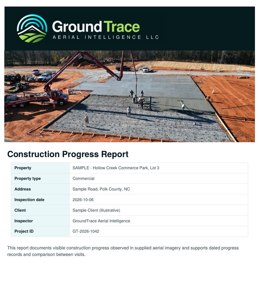
1A clear first page
Project, site, date and who it was prepared for, with a plain-English summary of what the visit found.
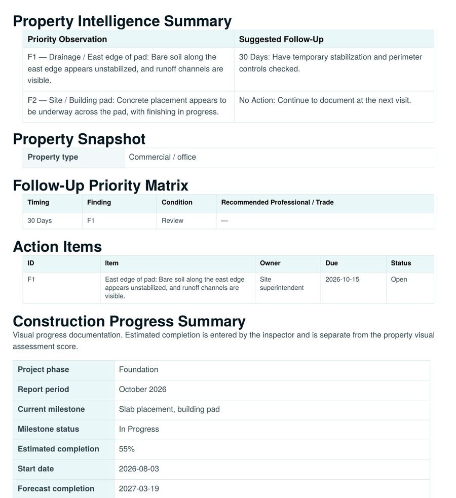
2Follow-up you can act on
A priority matrix and action items with an owner, due date and status for each item, so nothing gets lost between visits.
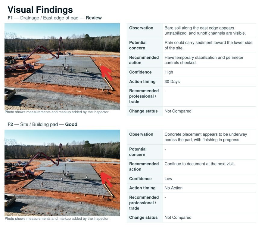
3Findings with marked-up photos
Each finding shows the photo, what is visible, why it might matter, a suggested action and a suggested timing.
Sample report. The photo and details shown are illustrative. Your report uses your own property photos, reviewed by a person before it reaches you.
Match the visits to the property.
Tell us about the property and what you want to keep an eye on, and we will recommend a schedule.
One-time baseline
A single documented visit to record current conditions.
Seasonal or annual
A regular check that lines up with the seasons or your maintenance plan.
Monthly or quarterly
A tighter schedule for managers with several properties or for sites that change quickly.
After a storm
A visit when severe weather has passed, documented against your baseline.
Simple packages. Clear starting prices.
Clear starting prices for typical properties. We confirm the scope with you before you commit.
Property Condition Review
$395baseline
A first dated record of your property, and the baseline for every visit after.
Delivered in 2 business days
Recurring Monitoring
from$325per visit
Consistent viewpoints and a concise comparison update after your baseline.
Baseline review comes first
Storm / Event Record
$475per event
A dated aerial record and event summary once severe weather has passed.
Delivered in 1 to 2 business days
Larger or more complex homes start at $695. Estates, several structures, or 5 to 15 acres are quoted after a look at the site, airspace and buildings.
Commercial, HOA and multi-building properties
Small Commercial
from$695
Up to about 25,000 sq ft or two buildings.
Standard Commercial
from$995
About 25,000 to 75,000 sq ft, or a more complex site.
Large / Multi-Building
from$1,495
About 75,000 to 150,000 sq ft, or several buildings.
Recurring Commercial
from$525per visit
Monthly or quarterly visits for managers and associations. Standard-size sites from $695 per visit.
What changes the price. Site size, number of visits, the deliverables you need and distance from our service base.
Travel. Travel within about 25 miles is included. Longer trips add a modest, quoted travel fee. Weather and airspace reschedules are never charged.
Simple for you.
-
Tell us about the property
Address, what matters most, and how often you would like visits.
-
We fly and document
Aerial photos from consistent viewpoints, on a day that suits the work.
-
You receive the report
A clear, dated report with findings, comparisons and next steps.
-
We keep the record
Each visit is added to the history so change is easy to see.
Job-site experience, applied to your property.
GroundTrace was started by someone with decades of experience in construction and civil sitework. Findings are worded plainly and stay within what the photos show. Every report is reviewed by a person before it reaches you.
- CertifiedFAA Part 107 remote pilot
- ExperienceDecades in construction and civil sitework
- CoverageWestern NC and Upstate SC
Request a property review.
Tell us about the property and what you want to monitor, document or keep track of. We will recommend a schedule that fits.
Prefer to talk first? Call (864) 680-1764 or email info@groundtraceaerial.com. Serving Western North Carolina and Upstate South Carolina.